Nootka Island July 2025
- Bob Dalton

- Nov 16, 2025
- 9 min read
Updated: Nov 19, 2025
Nootka Island is located on the west coast of Vancouver Island accessible via float plane (Air Nootka) or the MV Uchuck out of Gold River or other private boat services. Nootka is not a provincial park, it is the land of the Mowachaht/Muchalaht First Nation; it is important to acknowledge these land rights and express gratitude for our ability to access this beautiful place. You can purchase a pass to hike the Nootka Island Trail here. The trail is well documented on AllTrails but I recommend getting a copy of the Wild Isle Guide map for Nootka Island. There is something wonderful about a hard copy topographic map that digital cannot replace. We bought one from Air Nootka. We got to and from the island on Air Nootka which was awesome and reasonably priced but not the cheapest option. The staff at Air Nootka were great both in advance and during the trip. I had my Garmin Inreach with me and had Air Nootka setup to receive messages from my Inreach should that have been needed - it wasn't!
I first hiked the Nootka Trail in 2003 and returned in July of 2025 with my twin sons to experience it again. I expected to find it changed and crowded but I was pleasantly surprised to find that despite 20 years of population growth in the province the trail was relatively unchanged and not busy. The changes I noticed were all improvements - in particular the situation with outhouses has significantly improved. In 2003, there were none. Now there are vey nice, well maintained outhouses at each of the campsites we stopped at. Thanks very much to whoever it is that is managing that.
We started our trip from Burnaby on Thursday July 24th which meant being on the trail over the weekend which I wanted to avoid for fear of crowds which turned out to not be the case at all! We hiked full days on Friday, Saturday and Sunday and flew back out on Monday morning July 28th making it a 5 day trip in all including two travel days and three hiking days.
Day 1 (Thursday July 24th) - Home in Burnaby to Third Beach (very short hike)
Day 2 (Thursday July 25th) - Third Beach to Calvin Falls (14.5 km, elapsed time 6.5 hours)
Day 3 (Friday July 26th) - Calvin Falls to Beano Creek (11.5 km, elapsed time 4 hours)
Day 4 (Saturday July 27th) - Beano Creek to Yuquot / Friendly Cove (10ish km, my watch died, elapsed time 12 hours including a 4 hour wait for the tide to drop)
Day 5 (Sunday July 28th) - Yuqout back to Home (short walk in the morning)
If I do it again I would spend two nights at Third Beach to explore the north end of the island including the shipwreck noted on the map or even stay a night and the Oldham Beach Recreation Site noted on the Alltrails map. Alternatively if you can arrive early in the morning you would have plenty of time to explore the area, spend the night and continue south. Note that what I am calling Third Beach is not called Third Beach on the Wild Isle Guide map but it is on AllTrails. On the Wild Guide map I am referring to the camping spot closest to Louie Bay on the northwest end of the island. I have no idea where First and Second Beaches are, if anyone knows please educate me.
For this specific route (Louie Bay to Yuquot) I think three days of hiking is right. Strong hikers could easily do it in two but I think it would feel rushed and you would miss some great camping spots. They would also be long days, mostly due to the pebble beach sections if you miss low tide as walking on the pebbles can be slow. Four days would be quite leisurely but lovely so if you have time for that take the extra day. There is lots to explore and so much beauty to just sit and enjoy.
Day 1 - Home to Third Beach
We spent the morning driving from Burnaby to Gold River for a late afternoon flight. Our flight was delayed due to wind and low cloud which meant we didn't depart Gold River until about 5pm which was a much later start to our trip than planned. The Air Nootka office was being managed by Tyra who was super friendly and helpful. Our pilot was Scott who was professional and made us all feel comfortable. The flight was super bumpy which for me is quite awful but it's a short trip and the scenery is spectacular. We were dropped off at the head of Louie Bay and hiked the short distance (like 30 minutes max) to Third Beach where we setup camp. The trail is rugged as you might expect but not difficult as long as you have proper footwear. There is a nice creek running near the camp spots so fresh water is easily accessible. We carried an MSR Hyperflow Microfilter pump - I love this filter, you just need to make sure you backflush it regularly and carry a spare filter cartridge.
Third Beach was relatively busy, about 10 tents, but that was by far the busiest location we experienced. There are lots of places to camp along a big area so it didn't feel crowded.


Day 2 - Third Beach to Calvin Falls
14 km in 6.5 hours elapsed time with lots of breaks.
We didn't get going early enough to catch the low tide and stick to the beach for the first section of the hike south and were forced immediately into the the forest trail. Unlike the West Coast Trail, the Nootka Island trail is much more rugged which makes it slow but beautiful and enjoyable if you just take your time and embrace the rain forest.
After that first section in the forest we were back on the beach and the day had a bit of everything - forest trail, pebble beaches, sand beaches, sandstone shelf (often covered with seaweed) and some boulder sections. The weather was perfect and overall this was an amazing day. The pool at the base of Calvin Falls is a great swimming hole - the water is cool but not cold at this time of the season.


Day 3 - Calvin Falls to Beano Creek
12 km, 4 hours elapsed time. Easy walking.
We started hiking today at 8 am at low tide under blue skies though we were in and out of the fog all morning. Today was a gorgeous day of easy walking but beware that at high tide it would take a LOT longer because you would be forced to walk on the loose pebble sections of beach. The terrain was highly variable again today but enjoyable as we alternated between mostly sandstone shelf areas with bits of boulder field, pebble beaches and walking along logs which is really fun. We arrived at Beano at noon so we had lots of time to just relax and enjoy this beautiful space.
I love the campsites at Beano and we had the area almost to ourselves. Beano Creek ends in a large estuary separated from the Pacific by a high berm made of beach pebbles. I sat on the berm for hours just looking at pebbles and watching the waves. In the evening when the tide went back to its lowest point we walked out to the island just beyond the estuary. It's quite beautiful but in hindsight I'm not sure we should have done that as we likely killed a lot of muscles and other sea life through our walking.


Day 4 - Beano Creek to Yuquot
Today we hiked 10ish km over 12 hours. My watch battery died so I'm not sure exactly how far we went but it was something like 10-12 km. This turned out to be a much longer day on the trail than we planned - we had planned to hike about 2/3 of this and finish the trail the next morning to be ready for an afternoon pickup at Friendly Cove.
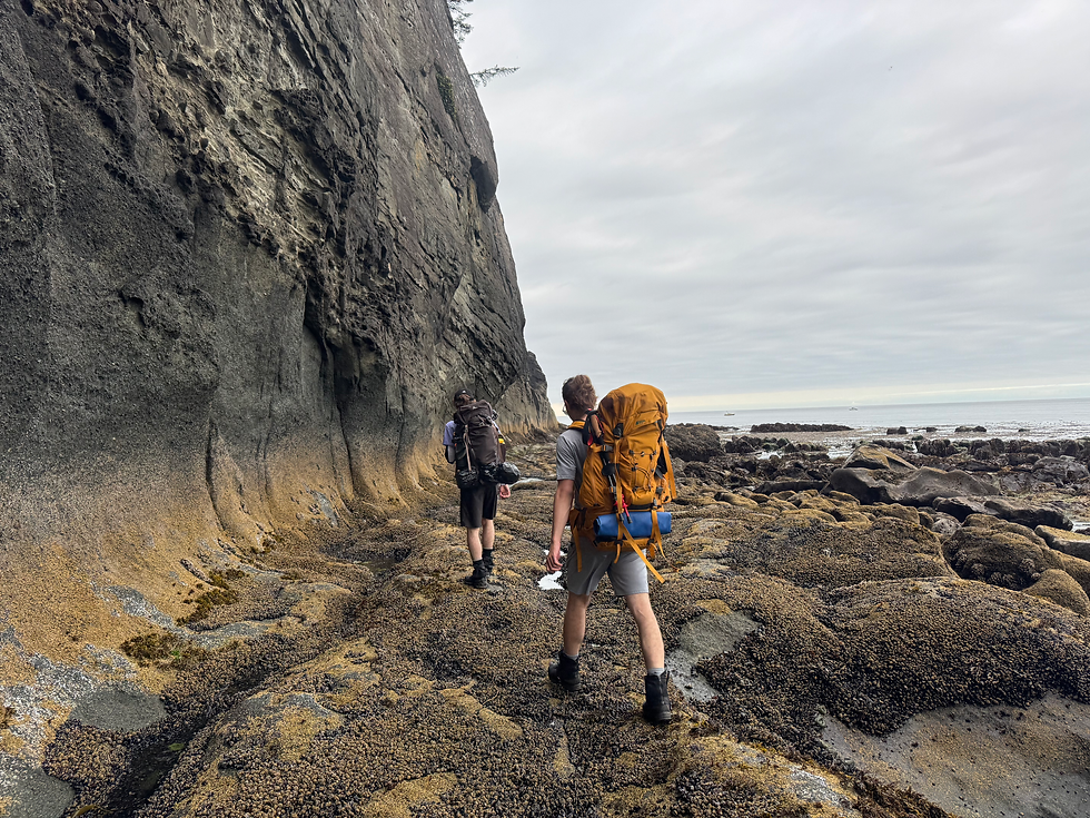
A word of caution with respect to this section of the trail. On the Wilde Guide map there is a section of trail that starks before the 25 km marker and ends just after it which is labeled "use bypass trail at higher tides to avoid cliff cutoff". I think this should say "Always use the bypass trail on this section!". We stayed on the beach and that turned out to be a bad decision. It is very difficult, slippery and dangerous boulder walking (albeit beautiful) until you arrive at a cliff with deep, rough ocean even with the tide at about its mid point. I guess it is possible that you can get through at low tide but we got there pretty early in the tide and there was no way to pass through. We turned around and made our way back through the boulders and onto the bypass trail in the forest.
All day we were in and out of the forest - up a steep section into the forest, down to a beach, across a beach and back up...really enjoyable but it is not easy walking like Calvin to Beano. We had planned to stop at the campsites after the 25km marker on the Wild Guide map or at the campsite after Maquinna Point. We got to the sites between the 25 and 30km markers quite quickly and the water sources there didn't look great so we kept going. I'm pretty sure when I did this trail in 2003 we camped at the site where the Wild Guide map says Seasonal Water, almost exactly half way between the 25 and 30km markers. In any case we kept going thinking that we would find better water at the campsites just beyond Maquinna Point but the water source there was REALLY bad from my perspective. There is a creek running into a very shallow pond, (labeled "water") on the Wilde Guide map, and the water looked stagnant, dark and filled with I don't know what. There was a group camped there who were unconcerned despite their filtered water looking like tea. It probably would have been ok, and the campsite is very nice, but I'm very cautious about water and so we pressed on.
The second word of caution with respect to this section is to make sure you are carrying enough water as the water sources are minimal.
We arrived at the lagoon Tsa'tsil at high tide. This is a beautiful spot but as the map indicates you can't cross until low tide - the water is very deep at high tide and the flow is very strong other than for a few minutes at slack tide. So we just settled in and relaxed for 4 hours waiting for the tide to drop at which point we continued on our way. We camped right on the beach just before Yuquot Point and got our drinking water from the Jewitt Lake which is about a hundred meters behind the beach. We had an amazing experience here with a gray whale who was rubbing herself in the pebbles - I was super excited when we first saw her as I thought this was a very rare moment! As it turned out she stay there all night, we could hear her blow hole all night, and she was still there in the morning. An amazing experience for us. Chatting with locals the next morning their were very nochalant about my description saying something like "oh ya, that gray is always hanging out there" like it's just no big deal.
: )


Day 5 - Friendly Cove to Home
I used my Inreach to contact Air Nootka last evening to request an earlier pickup at Friendly Cove and Tyra managed to arrange a flight at 930 am as opposed to the 6 pm that we had booked. Awesome! This allowed us to get all the way home on day 5.
Everyone we chatted with at Friendly Cove were indeed very friendly. In order to get to the dock for the MV Uchuck, Air Nootka or other pickup you need to pass some friendly locals including Sanford Williams who was happy to chat with us and show us his work. He was actively working on a pole and some doors for a hotel in Powell River.
We had an amazing trip and created some lasting memories.


Comments